With some weekdays available and a decent weather forecast, Katie and I headed out to the Chelan Sawtooths for some peakbagging, larch viewing and lake camping. This area is a long drive from Seattle but is always so worth the trip.
Our adventure began with a night in the car at Crater Creek Trailhead. The gravel road up to the trailhead was in great shape for us and was a breeze to drive at night. After a good night’s sleep, we packed our overnight gear and headed out at the casual hour of 10 am. One stark difference with the trails in the area compared to the ones I am more used to on the west side is that they are open to a wider variety of uses. It became immediately apparent as there were a few guys with loud motor bikes at the trailhead getting ready to ride out to and there was talk of a mountain bike race in the coming days.
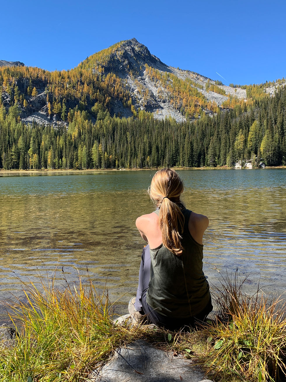
After a quick and easy 0.6 miles, we took a right turn at an intersection onto the Crater Lake Trail. This path was closed to bikes and was noticeably rockier and more full of roots. It was nice to be on a hiker only trail. The three miles up to Crater Lake went quickly, with larches starting to appear as we got closer to the lake. I was surprised that many of them were quite golden even though it was only September 21st. Crater Lake itself was a pretty awesome destination, ringed by golden larches and backed by rugged Sawtooth ridgelines. Crater Peak forms a nice pyramid when looking at the lake from the east. We took our time here having lunch and enjoying the great views and sunshine.

My plan for the trip was a bit fluid. I was hoping to connect all of the Bulger Peaks in the area but wasn’t quite sure how to pull that off. Looking at the map, I had an idea to carry our gear up and over Raven Ridge, hitting both high points in the process and then drop into the East Fork Buttermilk valley. Admittedly, I did not know what it would be like to descend off that side of Libby Peak on Raven Ridge but hoped that there was a way to connect with Hoodoo Pass.
With this tentative plan in place, we lugged our stuff all the way up Raven Ridge, essentially heading straight up from Crater Lake. The larch-filled woods down low provided easy open travel before transitioning into a massive jumble of boulders up high. These boulders were relatively stable, with only a few shifting under our weight. It was essentially just class 2 rock hopping to the summit. Near the summit, we came across a very cool rock “tunnel” formation that you could walk through.


Before we knew it, we had topped out on Raven Ridge! It was tough work, but views were great over the rest of the Sawtooths and towards Libby Lake and Hoodoo Peak, which had been a memorable trip the year before. It was special to be out here in larch season on a beautiful day.
At the top I was able to scope out our potential route over to Libby Peak on the west end of Raven Ridge, it looked like one giant boulder field that would go, but I was still suspicious of the route down to the East Fork Buttermilk. We made it down to the 8400’ notch below the main peak of Raven Ridge and it became apparent that the whole route up and over to Hoodoo Pass probably wasn’t in the cards for the day. It would entail hours of rock hopping and off-trail travel and would be a ton of work with our heavy packs. Doable, but Crater Lake was beckoning 1500’ feet below with its spacious lakefront campsites. We made the decision to bail from our intended route and camp at the lake that night.

By the time we had descended all that way (a more westerly descent route that worked just as well) we were grateful to just set the tent up and enjoy a nice evening at the lake. We found a giant campsite and spent a super comfortable night there. In scoping out the surrounding area that evening, I came up with a route that I thought could work to connect with Eagle Lakes. This would essentially involve aiming for a notch in the ridge to the east of Pt. 8022’. It looked like doable terrain, and I was hoping it would be similar on the south side. If it went, our full adventure could still be on!


The next morning dawned with high clouds, making it a bit brisker than the previous day of full sun. We set off following trail on the east side of Crater Lake. There was pretty good trail leading all the way up to the upper Crater Lake, which was shallower and smaller than its lower counterpart, but still stunning.

We were now much closer to my prospective route, and it was looking like it would go. We wound our way through some bright yellow larches before leaving them and ascending on big boulders and talus up towards the obvious notch. The boulders were mostly solid, similar to Raven Ridge, and travel actually wasn’t too difficult. We gained elevation fast, and soon were near the notch. Here, the ground was more hard-packed dirt and looser. Footing was more tenuous, but with care we were able to crest the ridge line without knocking any big rocks down.


I was thrilled that we had made it up to this point and the route on the south side looked good! It was a gentle slope off the other side, and we made a gradual skier's right descent in the direction of Upper Eagle Lake. Things were going well until things started to steepen below us considerably. The topo map didn’t explicitly show this, but there were some cliffy areas that you wouldn’t want to descend here. I was bummed by this development; we would need a break in the terrain to make this route work now. We traversed westward at about the 7600’ level and eventually found a steep crappy gully filled with short trees and loose dirt and rock that might work to get us down. I went first, proceeding cautiously and using some scrawny tree branches to lower myself through some of the steeper sections. Down lower, we each would go down a bit then get out of the fall line and wait for the other to descend to us. This method worked well, and before long the grade was lessening and we were rock hopping down to the valley floor. Overall, the descent was worse than I expected it would be, but I was thrilled that our gully worked well to get us down safely. Now we were done with any sketchy off-trail travel and our plans were back on!


It felt like a dream to be on flat ground and trail again and before long we were cruising into Upper Eagle Lake. This lake was stunning, set in a granite basin below the big cliffs of Mount Bigelow, with plenty of golden larches around. I have long said that parts of the Chelan Sawtooths remind me of the Enchantments with a tiny fraction of the people, and this lake was no exception. We found a great place to set up camp near where the trail dumps you onto the lakeshore. This would be a spectacular spot to spend the night.
Unfortunately, if I was to stay on track with my Bulger hunt, we would have to get moving again soon. This time, we shouldered daypacks and set out on the nice trail to Horsehead Pass. As we were about to start the switchbacks up to the pass, we spooked a black bear that was about 100 yards away in a meadow. It was interesting watching it gallop away through the tall grass. Once we crested the pass at about 7600’ we were greeted by a spectacular view and a few switchbacks down to Boiling Lake some 600 feet below us. The lake looks and feels remote.
The area around Boiling Lake was Katie’s end point for the day, so she accompanied me up through a beautiful larch grove to the 7400’+ pass south of the lake.


From there, my goal was to do Martin and Switchback as fast as possible and return to her at the lake. To get to Martin, I descended a bit from the pass and then began a rising traverse before heading straight up hill towards the saddle between Pt. 8270 and Martin. This area had some loose rock and sand and was kind of a pain, but nothing worse than typical Cascadian choss. I reached the saddle quickly and began the scramble up to Martin. This had some fun scrambling, all on easy class 2-3, but the area felt wild and moody with some darkening cloud cover. By the time I stood on the tallest summit rock, I was pulling out my puffy and hat from my backpack because it was pretty brisk.


I had made it up Martin much quicker than I had thought and quickly turned my sights toward Switchback. The ridge between the two looked fun but it was much further than I thought it would look. Nevertheless, I made the short descent off Martin and began heading south. The ridge was as fun as I thought it might be. It was broad and open, and I actually jogged some of it because I was feeling good and the terrain was easy. Before long I was making the final class 2 climb up Switchback. This part was kind of punishing because I was trying to push my speed, but it was over quick.

I was now standing on my second Bulger in the last 30 minutes or so. By now, the cloud layer had gotten a bit lower, and I was actually moving in and out of cloud on the summit. I was able to get a bit of a view down to Cooney Lake, though, which looked beautiful and completely surrounded by larches.

Because it was cold, and I was in a rush to get back to Katie at Boiling Lake I had a decision to make about how I wanted to return. My original thought was just to go back the way I came, but I knew there was a trail (#417) that was very near the summit of Switchback that could drop me off west into the valley. From there I could travel on easy trail all the way back to Boiling Lake, making for one big loop. This option would be longer, but I reasoned it would probably be faster. After lots of rough off trail travel my brain was ready to turn off and cruise so I opted for the trail. This was the right call, because after a series of steep switchbacks down I was able to make great time through the beautiful valley.


I did a little bit of jogging where appropriate and was back at the main trail intersection in the Middle Fork Prince Creek valley in no time. Here I was confronted with the only downfall in my chosen route, a 400 foot climb back up to the lake. It was daunting, but not too bad in reality and I was back to Katie, all in the span of about 2 fast-paced hours.

When I returned to the lake, Katie recounted seeing two black bears come down to the lake to swim and fish. I was jealous of her encounter and glad all parties involved stayed a safe distance from each other. Afternoon was starting to turn to evening, so we hustled up the switchbacks to Horsehead Pass and back down to our cozy camp at Upper Eagle to revel in a very successful day.

Day 3 was when we planned to hike out, but I had one more peak on the list: Mount Bigelow. I had read reports of people approaching Bigelow from both the west and the east, and I wasn’t sure what would be best for me. Looking at it from Upper Eagle Lake the night before, I decided that the east face looked steep and unpleasant, which meant I would once again have to head back up and over Horsehead Pass.
I took off early in the morning, starting in the 5 o’clock hour. It was pitch dark and despite getting the fright of my life from a ptarmigan on the trail I made quick work of the pass. On my way down, I bided my time to find the best place to leave it and cut across country. I had a track loaded from a previous party and was puzzled why they didn’t depart the main trail from the end of the big switchback. It was hard to see in the dark, so I ended up trusting them and taking off from the trail intersection at Boiling Lake. I immediately gained some elevation on easy terrain, and when it got harder, I aimed to stay between 7200’ and 7400’ as I traversed north. Going was slower here as it was still fairly dark. I tried my best to stay on game trails and pick my way through any trees or boulder fields in the most efficient way possible. Eventually I hit a spot around 7400’ where I just decided to head straight up. This way worked well, and I attempted to stay on solid rock as much as possible, but there was inevitably some loose stuff. The sun was just starting to come up as I reached the ridgeline of Mount Bigelow. Another quarter of a mile of easy class 2 ridge walking was necessary before I stood on top!


There were some amazing cliff faces on the east side of the mountain, and it was super cool to see Martin and Switchback out in the distance in one direction, and Raven Ridge in the other. I had covered a lot of ground in a couple days. The view down to Upper Eagle was also spectacular, and I noticed what might be a viable route down to the lake. I decided to test this out, because it would save me a ton of distance, and hopefully time, on my return to the lake. Despite the steep and rugged cliffs on Bigelow, there is one weakness leading off the summit and I followed it down.


Here I found surprisingly easy scrambling, and before long I had found tracks of people that had been up there before in the dirt and sand. I was able to scree ski down quite a way before hitting another obstacle. There was a bit of cliffy-ness on this side of Bigelow, and I needed to find a way through. In the area I checked I ran into a steep area that I wasn’t comfortable downclimbing around 7600’. It might have gone, but I had a hunch there was an easier way. I ended up going way out skier’s right and finding a rough, but much safer, way through this area. Before long I was circling the lake shore, returning to camp for breakfast before 9 with all 4 Bulgers in the bag.


Katie and I had a nice slow breakfast and warmed ourselves in the sun. The morning light hitting the larches at the lake was a sight to behold. Eventually, we packed all our stuff up and headed out, this time taking the Eagle Lakes Trail #431. This trail parallels the Crater Lake trail that we had come in on and would make for an awesome loop.
On the hike out, we ran into countless mountain bikers who were all steadily climbing up the trail to compete in a race that day. It amazed me that all these bikers were going out into such rugged and seemingly remote terrain to compete in an organized race. Hiking out we made sure to stay vigilant in case anyone was coming down behind us, but never had that happen. Eventually, we hit the trail intersection, and walked the final 0.6 miles back to our car, happy with another excellent larch trip. I felt great about getting all 4 Bulgers and also the route-finding and improvisation it took to make it happen.
Final Stats: 31.19 miles / 10,352 feet of gain

Comments