Berdeen Lake
- Sep 7, 2020
- 9 min read
Updated: Dec 17, 2025
9/5/2020 - 9/7/2020

There are some places in the Cascades that have a near magnetic pull on me. I love looking at maps of the mountains and dreaming of new places to visit and Berdeen Lake was near the top of my list. One look at a satellite image shows a large turquoise lake surrounded by rugged, glaciated peaks like Bacon and Blum. I had to see it with my own eyes!
I had concocted a plan for Labor Day Weekend that involved Katie and I hiking in to the lake on the first day, spending all of day 2 enjoying our time at the lake, and then hiking out the next day. Seemed simple enough, what could possibly go wrong?
The first part of the plan was to determine which direction to approach from. Getting to Berdeen Lake is difficult no matter what direction you approach from. I was very tempted to come from up and over Bacon Peak and down past Green Lake...this was guaranteed to be beautiful country but would be longer, involve glacier travel, and much more elevation gain. I was doubtful that this would fit into our three-day itinerary. Our other option was to ascend a forested ridge known as “Porkbelly Ridge” up from Bacon Creek. I knew there were at least some people that had approached this way, so I was hoping that it would be the path of least resistance.
Our first indication that the plan might be slightly misguided was when we were at the ranger station in Marblemount to pick up our permit. I said that we were hoping to go to the Berdeen Zone, and the ranger gave me a quizzical look before struggling to find it on the map. Despite the total lack of visitors, even on Labor Day weekend, I was still feeling good about the plan.
After driving the bumpy road down to the far point of the Bacon Creek Road, we set off into the unknown. Immediately, the old forest road we were meant to follow became less defined than I would have liked. We quickly found ourselves moving through open forest and only picking up traces of the road here and there. We eventually found a semblance of the road again, and after about a mile, we dropped down through thick foliage to cross the east fork of Bacon Creek. This spot was beautiful and wild, and the water was a deep bluish-green color. Even though travel had been harder than we expected, the river gave us some optimism for what lay ahead.

After crossing the knee-deep river barefoot, we were off again, picking up a faint path that we were relieved to find. Another sign of humans was the presence of some intermittent flagging with pink ribbons. We weren’t sure exactly what to trust, but it was at least a sign that we were on some kind of route. Only a brief bit of elevation gain brought us to a flat spot on the ridge at about 1200’. This part was comically terrible – downed trees were littering the ground in front of us, all encased in thick, jungle-like brush. We began bashing our way through, going over and under massive logs, and trying to maintain our balance. We couldn't trust our footing, because some of the logs were buried in brush and were so rotten that they would just crumble beneath our feet. There was one point where I stepped on what I thought was solid ground, but it gave way and sent me tumbling to the ground, snapping my trekking pole in half in the process. Thankfully, I wasn’t hurt at all, but it was still a “what are we doing out here?” moment. We couldn't even trust the ground we were stepping on!

We strongly considered just cutting our losses, turning around and finding a chill place to backpack for the weekend, but decided to press forward just a bit to see if there was any improvement. Luckily, the slope steepened, and the terrain became easier. There were less downed trees, and we could actually see the ground. We even found traces of boot path here and there and resolved to keep on heading up.
Travel on Porkbelly Ridge ranges from “ok” to “absolutely heinous”. In the ok sections, we were able to make up ground on steep, faint climber’s path, and in the absolutely heinous sections we were forced to bash our way through dense trees and bush that was unlike anything I’ve experienced before. The toughest sections were some of the worst suffering I’ve ever done in the mountains. We were beaten and bruised and defeated by the ridge, but somehow kept on going up. At a certain point, it became clear that our best option – even if we decided to turn around first thing in the morning – was to make it to the top of the ridge to camp. The slope was too steep and dense to set up a tent on, so up we went – mercifully emerging from the densest brush at 4800’ over 7 hours after we left the car.


We didn’t even come close to making my goal of going all the way to the lake in a day. I had totally underestimated just how terrible Porkbelly Ridge would be and was thankful to have found a bit of flat ground on the ridgetop. We stopped literally right as we crested the ridge and set up the tent – not having the energy to look for any other spots. We agreed to make our decision about the next day in the morning and drifted off to a well-earned sleep.
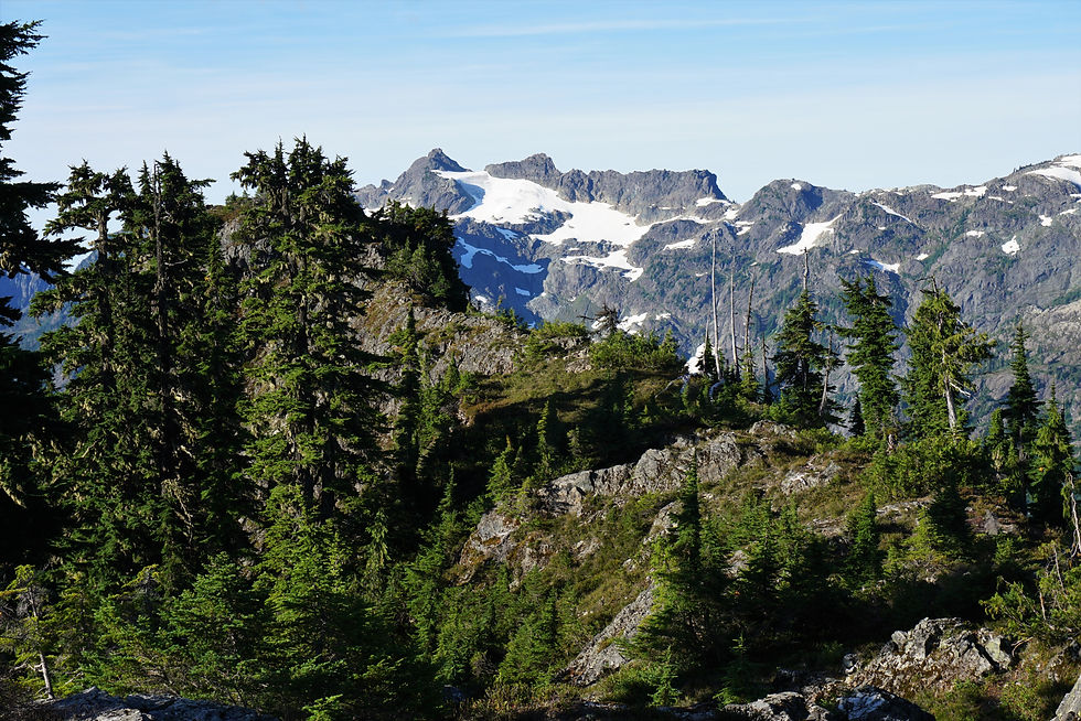
The next morning dawned beautiful and sunny, and it was a joy to wake up in such a cool spot. Views across the valley to Mount Despair and Triumph were exceptional – almost enough to forget about the suffering we had endured the day before.

Now that we were up on the ridge and the sun was shining, we had a bit more energy and decided we should see if we could get to the lake that day, so we packed up camp and started moving. The ridge was overall extremely pleasant compared to the day before. Open, lightly wooded terrain with nice views and some scrambling. A black bear was even following the same route for a while, and we followed at a respectful distance before it headed back into the woods.

At about 5100’ we came to a headwall and banked to the east to start a significant 700-foot descent down to a meltwater lake that was fed by a dying glacier or permanent snowfield. The lake was in a cool spot, and we took some time to fill up our waters and recharge before setting out on the final push to Lake Berdeen at 11:45. The lake would still not let anything be easy because the next section was an annoying mile of side-hilling on goat paths, steep heather, and loose rock. We tried our best to stay on firm ground, but it was exhausting travel – especially on the heather.


After an hour and a half, we FINALLY crested the pass and were able to see down to Lake Berdeen. Its waters were as turquoise as I imagined and the landscape was incredible, surrounded by Bacon Peak, Hagan Mountain and Mount Blum. The only problem is that our bodies were completely worked at this point. It had become clear that we weren’t going to have our casual day at the lake like we had thought. We went down to the lake, and I had one of the most incredible 20-second swims of my life, but the writing was on the wall that we would have to head back soon if we hoped to make it back to the ridge by dark.


It was an amazing feeling `to have made it to Berdeen Lake and swim in its frigid waters, but next time I resolved to budget more time and approach via Bacon Peak. With that decided, we reluctantly headed back the way we came after too short of stay. The fact that we had to experience everything we had just gone through in reverse was a daunting reality that faced us.
The slippery side-hill was rough on the return, but we were able to make it back to the meltwater lake, which was already shadowed in the evening light. Here our spirits picked up a bit as we washed off some dirt and grime and relaxed for a bit. I also thought I was starting to hear things, because after a day and a half of not seeing a soul, we heard voices. And sure enough, two other hikers came down to join us at the lake. I was shocked to see anyone, and it was fun to swap stories about Porkbelly Ridge with them.

They were heading the opposite direction, so we said our goodbyes and Katie and I began the 700-foot climb back up to regain the ridge. Here we found a nice tent site that was further north than our previous campsite. It felt great to have the tent set up before dark and enjoy the beautiful place we were in. We had made it to the lake (albeit briefly) and now only had to descend the ridge the next day.


The next morning, we again took some time to savor the beautiful place we were in. I liked that we were both able to take some moments to appreciate the beauty of this trip, despite the painful and at times miserable nature of getting there.

We packed up our gear and were moving along the ridge by 9:00 am in nervous anticipation of our descent. It wasn’t long before we dropped off into jungle hell, finding ourselves back in the thick of it. I tried my best to keep us following our up track, but we inevitably strayed a few times into steeper and more challenging terrain, that involved some tenuous veggie-belay traverses back to our desired path. About halfway down the ridge we took a break, and I emptied my pants pockets, which were filled to the brim with fir needles – giving you an idea of how thick the bushwhacking was.

Before long, we were navigating the flatter area near the bottom of the ridge, looking for pink ribbons and trying to avoid falling in the mess of fallen logs as best as possible. We mercifully popped out at Bacon Creek again, rejoicing when we saw its clear water. We took a nice swim in a deeper section of the creek, washing off some of the dirt and grime, and easing some of our cuts and bruises.
In our minds, we were essentially back to the car, with the vast majority of the hard travel behind us. Unfortunately, we messed up rejoining the old road-trail and encountered some of the worst bushwhacking of the whole trip fighting our way back up out of the creek. I’m still not sure how we got it so wrong, but eventually we were able to rejoin the “path” and follow it all the way back to our car. What an adventure.

I am determined to return to Berdeen Lake but am set upon a cross-country traverse up and over Bacon Peak and past Green Lake. I think that route will be even more scenic and essentially eliminate most of the heinous bushwhacking. I am ok with a bit more elevation gain to be on more pleasant, open terrain. I’ll also take a week or so to fully explore the area and take a more relaxed approach. One thing I will certainly not do is approach via Porkbelly Ridge again...probably.
Final Stats: 13.56 miles / 6428 feet of gain


Comments